The Most Difficult Hike in Phoenix, Ranked
Voting rules: Choose the hike you think is the most difficult!

Updated on Apr 27, 2024 06:24
Hiking enthusiasts often seek challenges that test their limits and skills, making the search for the toughest trails a common pursuit among avid adventurers. In an area like Phoenix, where the landscape offers a unique blend of desert and mountain terrain, identifying the hikes that present the highest difficulty can help prepare those who aim to conquer them. By ranking these paths, hikers can better select their next adventure based on real experiences and comprehensive feedback.
This dynamic listing empowers the hiking community by leveraging the collective experiences of its members. Each vote contributes to a clearer, more accurate depiction of each trail's challenges and features. Whether you're a seasoned hiker or someone looking to step up their game, participating in the ranking process not only aids in planning your hikes but also helps others in the community make informed decisions about where to cast their step next.
What Is the Most Difficult Hike in Phoenix?
-
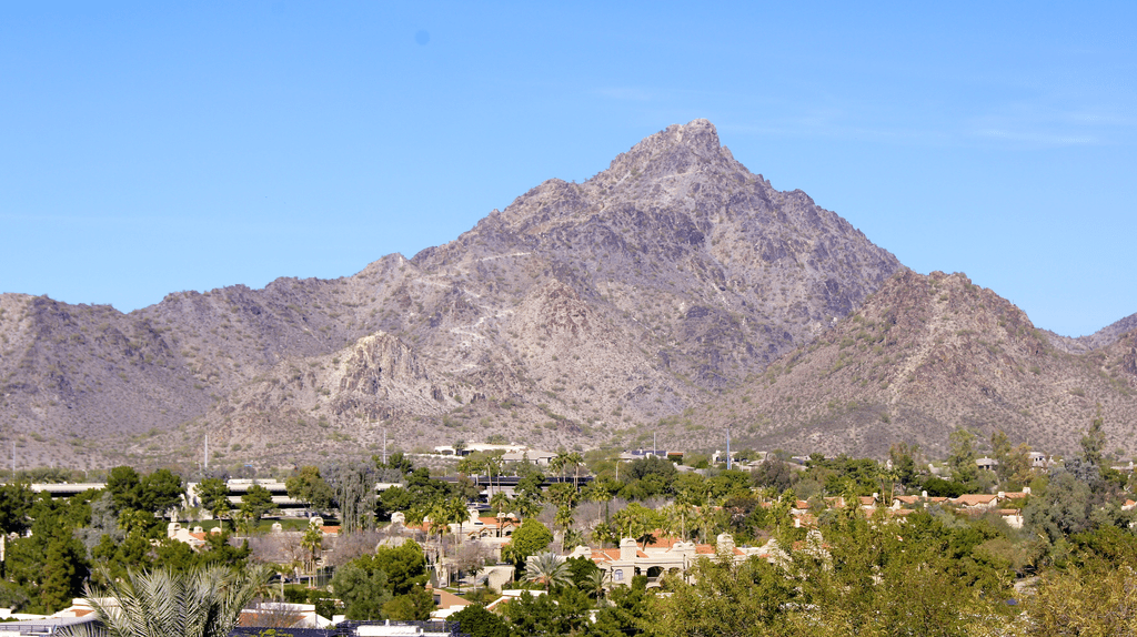
155votesThis is one of the most popular and difficult hikes in Phoenix, with steep inclines and rocky terrain. The summit offers stunning views of the city.Camelback Mountain is a challenging and iconic hiking trail located in Phoenix, Arizona. Rising to a height of 2,707 feet (825 meters), it offers breathtaking panoramic views of the surrounding Sonoran Desert and cityscape. The trail is known for its steep, rocky terrain, making it a rigorous and demanding hike suitable for experienced and fit hikers. The summit of Camelback Mountain is shaped like the hump of a camel, giving it its distinctive name. It is one of the most prominent natural landmarks in the Phoenix area and attracts numerous outdoor enthusiasts.
- Elevation: 2,707 feet (825 meters)
- Difficulty Level: Difficult
- Distance: 2.4 miles (3.9 kilometers)
- Elevation Gain: 1,280 feet (390 meters)
- Trail Type: Out and back
-
229votesFormerly known as Squaw Peak, this hike is known for its steep inclines and rocky terrain. The summit offers panoramic views of the city.Piestewa Peak is a prominent mountain summit located in the Phoenix Mountains Preserve in Phoenix, Arizona. It offers a challenging hiking trail that attracts both locals and visitors seeking a strenuous outdoor adventure. The trail provides panoramic views of the surrounding Sonoran Desert and the cityscape of Phoenix.
- Elevation: 2,608 feet (795 meters)
- Trail Length: 1.2 miles (1.9 kilometers)
- Difficulty Level: Moderate to Difficult
- Trail Type: Out and back
- Elevation Gain: 1,190 feet (363 meters)
-
314votes
South Mountain
City of PhoenixThis is the largest municipal park in the country and boasts several challenging hikes, including the Summit Trail, which offers views of the city and surrounding mountains.South Mountain Park/Preserve, also known as South Mountain, is a rugged mountain range located in Phoenix, Arizona. It is the largest municipal park in the United States, covering approximately 16,000 acres. South Mountain offers a variety of challenging hiking trails that are popular among outdoor enthusiasts.- Location: Phoenix, Arizona
- Size: 16,000 acres
- Trail Difficulty: Moderate to difficult
- Elevation Gain: Up to 2,330 feet
- Trail Length: Ranges from 1 to 14 miles
-
410votes
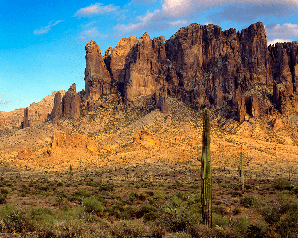 Photographed by Doug Dolde; · Public domainThis range offers several challenging hikes, including the challenging Flatiron Trail, which offers breathtaking views of the Sonoran Desert.
 -
513votes
Hieroglyphic Trail
UnnamedThis hike is known for its steep inclines and rocky terrain, but rewards hikers with views of ancient petroglyphs.The Hieroglyphic Trail is a challenging hike located in the Superstition Mountains near Phoenix, Arizona. The trail offers breathtaking desert scenery and leads to ancient petroglyphs carved by Native Americans many years ago. It is a popular choice for experienced hikers seeking a strenuous adventure.- Location: Superstition Mountains, Phoenix, Arizona
- Difficulty Level: Hard
- Length: Approximately 3.2 miles round trip
- Elevation Gain: 1,052 feet
- Trail Type: Out and back
-
615votes
Tom's Thumb Trail
McDowell Sonoran ConservancyThis hike offers challenging terrain and a steep ascent to the summit, which offers stunning views of the surrounding area.Tom's Thumb Trail is a challenging and exhilarating hiking trail located in the McDowell Sonoran Preserve in Phoenix, Arizona. It offers breathtaking views of the surrounding desert landscape and is known for its difficult terrain and steep ascent. The trail is approximately 4.5 miles long and is rated as highly strenuous, making it suitable for experienced hikers seeking a challenging adventure. The trail was named after a prominent rock formation called Tom's Thumb, which can be seen along the route.- Length: 4.5 miles
- Difficulty: Highly strenuous
- Elevation Gain: 1,365 feet
- Trail Type: Out and back
- Scenic Views: Panoramic desert views
-
79votesThis hike offers a challenging ascent to the summit, which offers views of the city and surrounding mountains.Shaw Butte is a challenging hike located in Phoenix, Arizona. It features a steep ascent to the summit of a prominent volcanic mountain, offering breathtaking views of the surrounding desert landscape.
- Elevation: 2,149 feet
- Trail Length: approximately 4 miles roundtrip
- Difficulty Level: Moderate to Difficult
- Elevation Gain: about 880 feet
- Trail Type: Loop
-
88votes
 Whpq · CC BY-SA 3.0This hike offers steep inclines and rocky terrain, but rewards hikers with stunning views of the city and surrounding mountains.North Mountain is a challenging hiking trail located in Phoenix, Arizona. It is a prominent feature of the Phoenix Mountains Preserve and offers breathtaking panoramic views of the city skyline and surrounding desert landscape.
- Location: Phoenix, Arizona
- Elevation: 2,104 feet (641 meters)
- Length: Around 3 miles (4.8 kilometers) round trip
- Difficulty: Strenuous
- Trail Type: Out and back
-
99votes
 GreenGibbon · CC BY-SA 3.0
McDowell Mountains
Natural geological formationThis range offers several challenging hikes, including the challenging Tom's Thumb Trail, which offers stunning views of the surrounding area.The McDowell Mountains is a mountain range located in the northeastern part of the Phoenix metropolitan area in Arizona. It offers a challenging and exhilarating hiking experience for outdoor enthusiasts. The rugged terrain, steep elevation gains, and panoramic vistas make it one of the most difficult hikes in the Phoenix area.- Elevation: The highest peak, East End, reaches 4,048 feet (1,234 meters) above sea level.
- Trail Length: The McDowell Mountain Preserve boasts over 200 miles (321 kilometers) of various trails, offering options for both short and long hikes.
- Difficulty Level: The McDowell Mountains are considered challenging and are recommended for experienced hikers. The steep ascents and descents, rough terrain, and variable weather conditions make it a demanding and strenuous hike.
- Scenic Views: Hikers can enjoy breathtaking panoramic views of the surrounding Sonoran Desert, Phoenix, and the nearby Tonto National Forest.
- Flora and Fauna: The McDowell Mountains are home to a diverse range of desert vegetation, including saguaro cactus, palo verde trees, and various wildlife species such as coyotes, javelinas, and desert tortoises.
-
103votesThis hike offers challenging terrain and a steep ascent to the summit, which offers stunning views of the surrounding area.Black Mountain is a prominent peak located in the city of Phoenix, Arizona. It is an iconic landmark in the area, offering a challenging and rewarding hiking experience for outdoor enthusiasts. Rising to an elevation of 2,314 feet (705 meters), it provides breathtaking panoramic views of the surrounding desert landscape. The trail to the summit is steep and rocky, requiring a good level of fitness and hiking experience. The Black Mountain trail is a popular choice for hikers looking for a challenging adventure in the Phoenix area.
- Elevation: 2,314 feet (705 meters)
- Location: Phoenix, Arizona
- Difficulty: Moderate to Difficult
- Trail Length: 2.6 miles (4.2 kilometers)
- Elevation Gain: 1,345 feet (410 meters)

Missing your favorite hike?
Graphs
Discussion
Ranking factors for difficult hike
-
Trail lengthA longer trail means more distance to cover, which contributes to the overall difficulty of the hike.
-
Elevation gainElevation gain refers to the total ascent during the hike. Steeper trails with more uphill climbs are typically more challenging.
-
TerrainThe nature of the trail, such as rocky surfaces, loose gravel, uneven ground, or technical sections, can affect the difficulty of a hike.
-
Climate and weather conditionsPhoenix can experience extreme heat in the summer months, making hikes more challenging due to the increased risk of dehydration and heat exhaustion. Hiking during cooler months or early mornings can help mitigate this risk.
-
Fitness levelHikers with a higher level of fitness may be able to tackle more challenging trails in Phoenix. It's essential to know your limits and choose hikes that align with your current fitness level.
-
AltitudeHigher altitude hikes can be more challenging due to thinner air and lower oxygen levels, which can lead to altitude sickness in some individuals.
-
Time commitmentMore difficult hikes in Phoenix may require a greater amount of time to complete. Make sure you have enough time and daylight to finish the hike safely.
-
Access and remotenessSome hikes may be more difficult to access or more remote, requiring additional preparation, such as packing extra supplies or having a reliable navigation system.
-
Experience and skill levelMore challenging hikes might require prior hiking experience or specific skills such as rock scrambling, navigation, or technical knowledge.
-
Trail conditionsCheck the current trail conditions before attempting a hike, as recent weather events or trail maintenance work can impact the hike's difficulty. This information can often be found on local park websites or through local hiking forums.
About this ranking
This is a community-based ranking of the most difficult hike in Phoenix. We do our best to provide fair voting, but it is not intended to be exhaustive. So if you notice something or hike is missing, feel free to help improve the ranking!
Statistics
- 2141 views
- 165 votes
- 10 ranked items
Voting Rules
A participant may cast an up or down vote for each hike once every 24 hours. The rank of each hike is then calculated from the weighted sum of all up and down votes.
Trendings topics
Don't miss out on the currently trending topics of StrawPoll Rankings!
Adventure
- The Most Handsome Musician in Liberia: Ranking the Country's Style Icons
- The Most Popular Musician in Poland: A Ranking of Polish Musical Favorites
- The Most Famous Gospel Musician: A Ranking of Renowned Artists
- The Most Famous Classical Trumpet Players: Celebrating Legendary Talent
- The Most Beautiful Musician in Ghana: A Ranking of Ghana's Musical Gems
- The Most Famous Steel Guitar Player: A Ranking-based Assessment of Legends
Outdoor Recreation
Difficulty Levels
More information on most difficult hike in phoenix
Phoenix, Arizona is renowned for its awe-inspiring natural landscapes and challenging hiking trails. With over 200 miles of trails, there are plenty of options for hikers of all levels. However, for those seeking a truly challenging experience, there are a few hikes that stand out above the rest. From steep inclines to rocky terrain, these trails require a combination of physical endurance and mental fortitude. Whether you're a seasoned hiker or a beginner looking to push your limits, the most difficult hikes in Phoenix are sure to test your skills and leave you with a sense of accomplishment. So, get ready to lace up your boots and tackle some of the most challenging trails in the Southwest!
Explore other rankings
Check out some of the other recommended rankings on StrawPoll and make your voice heard.